


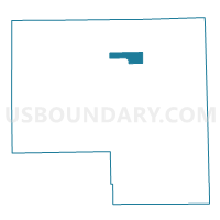
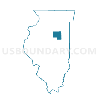
ODELL 2 Voting District, Livingston County, Illinois
About
Outline

Summary
| Unique Area Identifier | 572654 |
| Name | ODELL 2 Voting District |
| County | Livingston County |
| State | Illinois |
| Area (square miles) | 8.63 |
| Land Area (square miles) | 8.61 |
| Water Area (square miles) | 0.02 |
| % of Land Area | 99.81 |
| % of Water Area | 0.19 |
| Latitude of the Internal Point | 41.00757600 |
| Longtitude of the Internal Point | -88.51742310 |
Maps

Graphs
Select a template below for downloading or customizing gragh for ODELL 2 Voting District, Livingston County, Illinois


Neighbors
Neighoring Voting District (by Name) Neighboring Voting District on the Map
- DWIGHT 4 Voting District, Livingston County, IL
- ESMEN Voting District, Livingston County, IL
- NEVADA Voting District, Livingston County, IL
- ODELL 1 Voting District, Livingston County, IL
- SUNBURY Voting District, Livingston County, IL
- UNION Voting District, Livingston County, IL
Top 10 Neighboring County Subdivision (by Population) Neighboring County Subdivision on the Map
- Dwight township, Livingston County, IL (4,494)
- Nevada township, Livingston County, IL (1,335)
- Odell township, Livingston County, IL (1,276)
- Esmen township, Livingston County, IL (326)
- Union township, Livingston County, IL (240)
- Sunbury township, Livingston County, IL (229)
Top 10 Neighboring Place (by Population) Neighboring Place on the Map
Top 10 Neighboring Elementary School District (by Population) Neighboring Elementary School District on the Map
- Dwight Common School District 232, IL (6,317)
- Odell Community Consolidated School District 435, IL (1,440)
Top 10 Neighboring Secondary School District (by Population) Neighboring Secondary School District on the Map
- Pontiac Township High School District 90, IL (16,496)
- Dwight Township High School District 230, IL (6,605)